File:OSDI-spd-dirn.png
Jump to navigation
Jump to search


Size of this preview: 800 × 345 pixels. Other resolutions: 320 × 138 pixels | 1,773 × 764 pixels.
Original file (1,773 × 764 pixels, file size: 60 KB, MIME type: image/png)
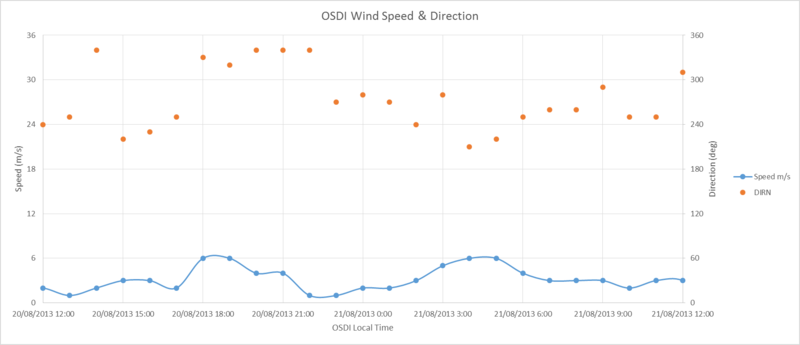
Wind Speed and Direction at OSDI (Damascus Airport) for August 20/21 2013 using ICAO METARS data via navlost.eu
Data is measured at 10 m above ground level at a site on the airport grounds.
OSDI Elevation AMSL 2,020 ft / 616 m, location 33°24′41.48″N 36°30′56.01″E
File history
Click on a date/time to view the file as it appeared at that time.
| Date/Time | Thumbnail | Dimensions | User | Comment | |
|---|---|---|---|---|---|
| current | 09:15, 29 October 2013 |  | 1,773 × 764 (60 KB) | Charles Wood (talk | contribs) | Wind Speed and Direction at OSDI (Damascus Airport) for August 20/21 2013 using ICAO METARS data via navlost.eu |
You cannot overwrite this file.
File usage
The following page uses this file: