File:MH17 impact point via aviaforum.jpg
Jump to navigation
Jump to search


Size of this preview: 800 × 464 pixels. Other resolutions: 320 × 186 pixels | 2,356 × 1,367 pixels.
Original file (2,356 × 1,367 pixels, file size: 467 KB, MIME type: image/jpeg)
- Description
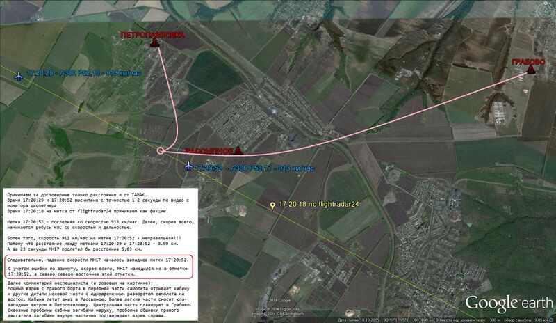
- The video from Russian Ministry of Defense includes playback of Russian civilian radar record. Based on it, a participant of aviaforum.ru determined coordinates of the missile strike:
- Meteo: 757.2 mm Hg at sea level. Flight level 33000 feet = 10058 m, pressure correction 2,8 mm Hg = 34 m, altitude 10024 m (please check my calculations).
- Source
- aviaforum.ru: http://sf.uploads.ru/cUoK2.jpg (registration required)
- Via http://www.pprune.org/rumours-news/543733-mh17-down-near-donetsk-59.html#post8602360
File history
Click on a date/time to view the file as it appeared at that time.
| Date/Time | Thumbnail | Dimensions | User | Comment | |
|---|---|---|---|---|---|
| current | 01:28, 11 August 2014 |  | 2,356 × 1,367 (467 KB) | Petri Krohn (talk | contribs) | ;Source * aviaforum.ru: http://sf.uploads.ru/cUoK2.jpg (registration required) * Via http://www.pprune.org/rumours-news/543733-mh17-down-near-donetsk-59.html#post8602360 Category:Maps Category:MH17 |
You cannot overwrite this file.
File usage
The following page uses this file: