File:Turkish-Syrian border at Öncüler.jpg

Original file (1,920 × 1,200 pixels, file size: 409 KB, MIME type: image/jpeg)
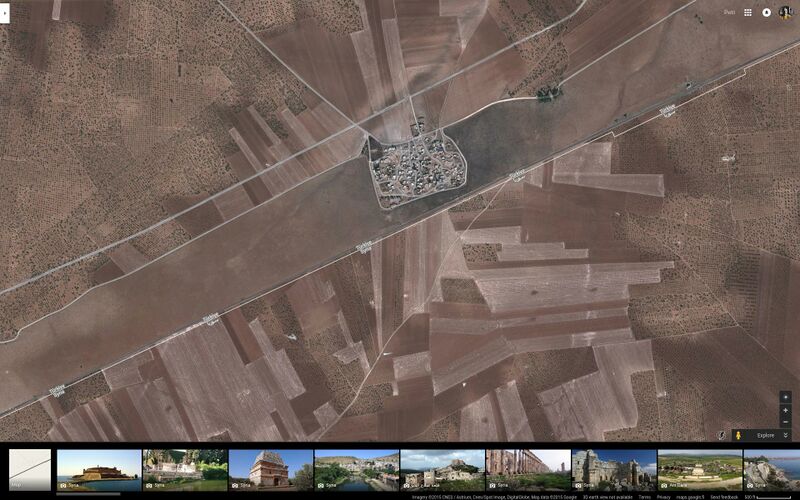
The Turkish-Syrian border at Öncüler, some 20 km west of Jarablus.
The border between Turkey and Syria is almost as impregnable as the Inner German border between #DDR and West Germany. a 250 meters wide minefield separates Syria from Turkey proper. South of this minefield runs the old (Berlin to) Istanbul to Baghdad railroad on a 10 meters wide strip on the Turkish side of the border. South of the border Syrian fields extend right up to the railway.
This no-man's land and minefield was created to stop Kurdish "terrorist" from entering or leaving Turkey. The minefield extend from Hatay in the West to Iraq and beyond. If it can stop PKK it could as well stop ISIS and al-Nusra.
The only part of the border still controlled by terrorists on the Syrian side is 100 km West of the Euphrates between Azaz and Jarablus in Aleppo Government. Turkey has now moved hundreds of tanks and APCs and 30,000 troops to this area ostensibly to "seal the border" and stop ISIS supplies and terrorist crossing.
File history
Click on a date/time to view the file as it appeared at that time.
| Date/Time | Thumbnail | Dimensions | User | Comment | |
|---|---|---|---|---|---|
| current | 00:33, 1 December 2015 |  | 1,920 × 1,200 (409 KB) | Petri Krohn (talk | contribs) | The Turkish-Syrian border at Öncüler, some 20 km west of Jarablus. The border between Turkey and Syria is almost as impregnable as the Inner German border between #DDR and West Germany. a 250 meters wide minefield separate... |
You cannot overwrite this file.
File usage
The following page uses this file: