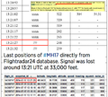
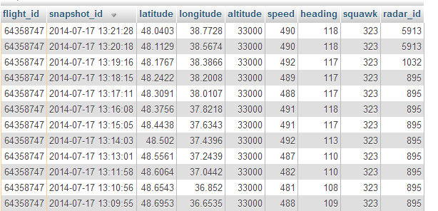
File:MH17 Flightradar24 database.png
MH17_Flightradar24_database.png (614 × 296 pixels, file size: 135 KB, MIME type: image/png)
- Source
- Flightradar24 on Twitter - 7:20 PM EET- 17 Jul 2014
- SoCalBrian on Flightradar24 forum, 2014-07-17, 15:31: Thread: Malaysian B777 MH17 crash - poss shot down -
- Pinned flight on FlightRadar24 site (less precise data)
- Confirmation
- Flightradar24 @flightradar24 Jul 24
- @ArtWendeley @PetriKrohn Data in the image is not interpolated, it is 100% transponder data.
Mike on FlightRadar24 forum (Mike / Mikael Robertsson is an admin at the FlightRadar24 forum)
- We are very well aware of that the crash site is 15 km before last signal. Currently we can't explain it on any other way than winds or maybe aircraft turning around if it lost a wing or stabilizer (Wild speculation. I don't say it happened, just say that this could explain why aircraft turned back). We will have to wait for the black box data to get the answers. I for sure trust the data we have received and it looks like our data can be confirmed by another source
- The heading was recorded by FR24 and was published 3 hours after the crash
- https://twitter.com/flightradar24/st...06795725348864
- Before MH370 almost no media trusted FR24 data. During the first 10 hours after it disappeared I contacted every big media in the world to tell them that signal was lost outside of Malaysia, and not in China where the search was focused on for first 10 hours. No one cared. After some weeks it was found that FR24 had the last tracked data of MH370 and that it was correct. After that we gained some confidence in media.
- When MH17 disappearance was announced it took only about 5 minutes for FR24 to become overloaded as everybody was looking for FR24 as the primary source for data. We posted our raw data from database about 3 hours after the crash, and as far as I have seen this is the best data we have today. Several journalist have called us to verify 13:21 UTC as the time when last signal was picked up and I have seen this time in several media around the world. Example: http://www.theguardian.com/world/gra...th-map-ukraine
- Some media use other timings with everything between 13:00 and 14:00 as last signal time.
- There are 200+ mentions on Google with last position: https://www.google.com/webhp?sourcei...+%2238.7728%22 (this search is just matching on the raw data, there could be more mentions with less decimals, conversion to other format or just a map).
- FlightAware
There is one additional datapoint available on FlightAware. The source of the data is indicated as WMSA / SZB or Sultan Abdul Aziz Shah Airport in Malaysia. Evidently this was somehow relayed over satellite.
- Thu 03:19:59 PM 48.1350 38.5030 117° Southeast 494 kts 568 mps 33,000 ft ADS-B (WMSA / SZB)
Discussion
Spoofing transponder data
- Spoofed radar ID caused MH-17 shoot down - Guy Smiley, Red Flag News, July 22, 2014
Primary vs Secondary Radar
Secondary radar receives plane's transponder signal which includes ID and may include altitude. Thus faking secondary radar data should not be too cumbersome, put transponder on another plane and let it squak your song. Primary radar- is actually a radar, measures time delay, angle , Dopler frequency shift. Faking that will 'have higher costs imposed'.
Buk Tellar does not really care about a transponder, it uses an actual radar, and in the minimal configuration, just a Tellar, does not do friend or foe ID. It locks onto something seen on radar and than missile tries to navigate there. It will go to the center of mass of what it locked on.
File history
Click on a date/time to view the file as it appeared at that time.
| Date/Time | Thumbnail | Dimensions | User | Comment | |
|---|---|---|---|---|---|
| current | 23:36, 6 June 2017 |  | 614 × 296 (135 KB) | Petri Krohn (talk | contribs) | Reverted to version as of 17:52, 30 July 2014 (UTC) |
| 23:35, 6 June 2017 |  | 739 × 664 (423 KB) | Petri Krohn (talk | contribs) | Source: http://mh17.webtalk.ru/viewtopic.php?id=460&p=10#p60721 | |
| 17:52, 30 July 2014 |  | 614 × 296 (135 KB) | Petri Krohn (talk | contribs) | ;Source * Flightradar24 on Twitter Category:Maps Category:Documents Category:MH17 |
You cannot overwrite this file.
File usage
The following 2 pages use this file:
