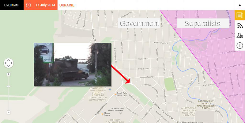
File:LiveUAmap Lugansk July17.png
Jump to navigation
Jump to search


Size of this preview: 800 × 401 pixels. Other resolutions: 320 × 160 pixels | 1,024 × 513 pixels.
Original file (1,024 × 513 pixels, file size: 413 KB, MIME type: image/png)
Vincent Verweij @vverweij
- @EliotHiggins @bellingcat @correctiv_org And I noticed that the BUK was driving thru government controlled territory
- @EliotHiggins @bellingcat @correctiv_org I was using Liveuamaps when in Ukraine, reporting for Dutch TV. They're dead accurate.
- @EliotHiggins @correctiv_org No they would have been able to approach from the north. Here's a wider view of the map.
- Source
- Vincent Verweij @vverweij on Twitter
- https://twitter.com/vverweij/status/554741270669967361/
- https://twitter.com/vverweij/status/554743255599181825/
File history
Click on a date/time to view the file as it appeared at that time.
| Date/Time | Thumbnail | Dimensions | User | Comment | |
|---|---|---|---|---|---|
| current | 22:32, 5 May 2015 |  | 1,024 × 513 (413 KB) | Petri Krohn (talk | contribs) | Vincent Verweij @vverweij :''@EliotHiggins @bellingcat @correctiv_org And I noticed that the BUK was driving thru government controlled territory :''@EliotHiggins @bellingcat @correctiv_org I was using Liveuamaps when in Ukraine, reporting for Dutc... |
You cannot overwrite this file.
File usage
There are no pages that use this file.