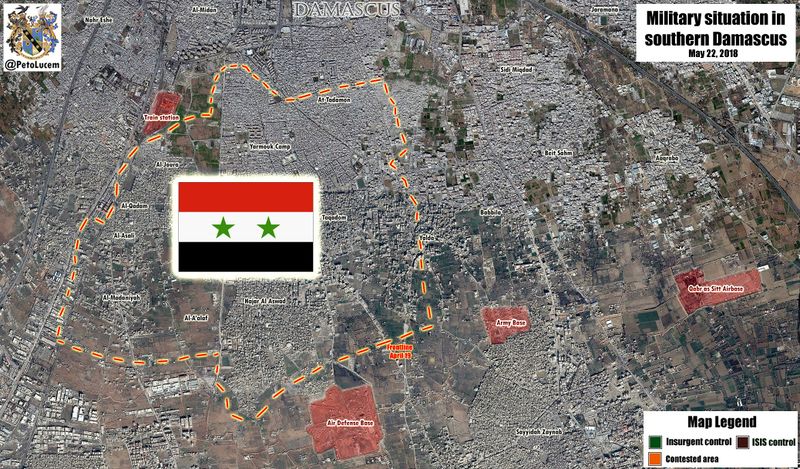
File:Frontlines Southern Damascus.jpg
Jump to navigation
Jump to search


Size of this preview: 800 × 469 pixels. Other resolutions: 320 × 188 pixels | 2,075 × 1,216 pixels.
Original file (2,075 × 1,216 pixels, file size: 1.14 MB, MIME type: image/jpeg)
Source: PetoLucem
File history
Click on a date/time to view the file as it appeared at that time.
| Date/Time | Thumbnail | Dimensions | User | Comment | |
|---|---|---|---|---|---|
| current | 21:54, 22 May 2018 |  | 2,075 × 1,216 (1.14 MB) | CE (talk | contribs) | NEW MAP: Battle of #Damascus is over. #ISIS remnants abandoned all of their positions in exchange for transportation to the Badiya Al-Sham region of eastern #Syria. For the first time since 2011 Syria's capital and its countryside are under full govern... |
| 11:47, 12 May 2018 |  | 2,075 × 1,216 (1.17 MB) | CE (talk | contribs) | The evacuation process of the last "rebels" in/near #Damascus has been completed. #Babbila, #BeitSahm and #SidiMiqdat are now under full Government control. Pressure on remaining #ISIS forces in #Yarmouk Camp area will likely increase now. https://twit... | |
| 12:46, 9 May 2018 |  | 2,075 × 1,216 (1.17 MB) | CE (talk | contribs) | Following recent #SAA advances, #ISIS remnants in southern #Damascus are increasingly under pressure at #Yarmouk camp. https://twitter.com/PetoLucem/status/994123511080914944 | |
| 13:01, 6 May 2018 |  | 2,075 × 1,216 (1.16 MB) | CE (talk | contribs) | Soon, all areas in and near #Damascus will be under full Government control. #SAA eliminated #ISIS remnants in Hajar Al Aswad and "rebel" groups east of the last #IslamicState pocket at #Yarmouk Camp have surrendered. https://twitter.com/PetoLucem/stat... | |
| 17:14, 3 May 2018 |  | 2,075 × 1,216 (1.16 MB) | CE (talk | contribs) | #SAA forces and Palestinian allies split the #ISSI pocket in southern #Damascus and separated #Yarmouk Camp from Hajar Al Aswad district. https://twitter.com/PetoLucem/status/992089159689895936 | |
| 12:39, 29 April 2018 |  | 2,075 × 1,216 (1.16 MB) | CE (talk | contribs) | #SAA and allied Palestinian forces scored a huge advance against #IslamicState militants in southern #Damascus amid a total collapse of #ISIS defenses. Government forces liberated Al-Asali + Al-Jorah neighborhoods and Al-Qadam district. https://twitter... | |
| 12:38, 29 April 2018 |  | 2,075 × 1,216 (1.15 MB) | CE (talk | contribs) | #SAA forces and allied Palestinian militias have liberated Al-Madaniyah and areas north of Al-Joura district from #ISIS. https://twitter.com/PetoLucem/status/990237156508688384 | |
| 17:11, 22 April 2018 |  | 2,075 × 1,216 (1.15 MB) | CE (talk | contribs) | https://twitter.com/PetoLucem/status/987973883088302081 | |
| 15:09, 16 April 2018 |  | 2,075 × 1,216 (1.14 MB) | CE (talk | contribs) | Source: [https://twitter.com/PetoLucem/status/985566553822433282 PetoLucem] Category:Maps |
You cannot overwrite this file.
File usage
The following 2 pages use this file: