File:Barzeh control 2 September 2013.jpg
Jump to navigation
Jump to search


Size of this preview: 800 × 421 pixels. Other resolutions: 320 × 168 pixels | 960 × 505 pixels.
Original file (960 × 505 pixels, file size: 146 KB, MIME type: image/jpeg)
- Description
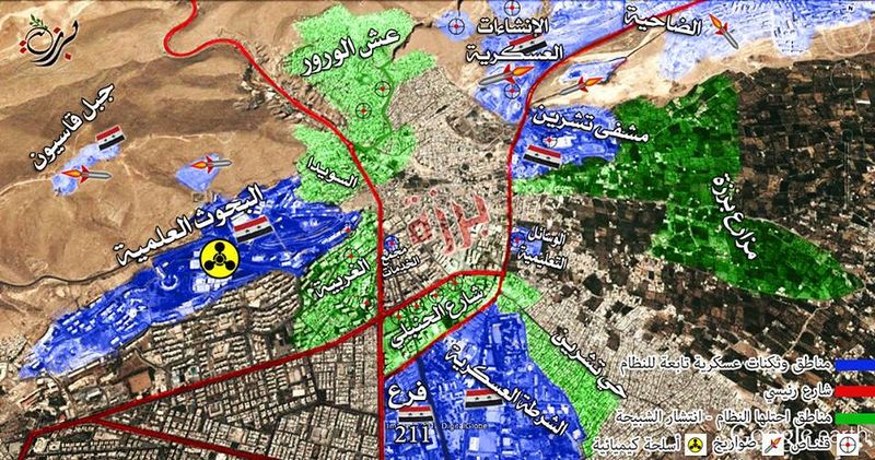
- خارطة لحي برزة الدمشقي تظهر تجمعات الأمن و الشبيحة و الثكنات العسكرية والأحياء الموالية للنظام التي تحيط بالحي.
- Map of Barzeh neighborhood of Damascus security groupings appear, shabeeha and military barracks and pro-regime neighborhoods surrounding neighborhood.
Green:
- Barzeh Orchards
- 'Ash Al-Warwar (northwest half)
- Teshreen Neighborhood
- Barzeh Al-Balad (south)
- Barzeh Hamich (east)
Government control
- Barzeh Al-Balad (central)
- Barzeh Hamich (central)
- Qaboun military compounds
- Tishreen Military Hospital
- Source
- تنسيقية الثورة السورية في حي الميدان المجاهد (Syrian Revolution coordination in the field struggling neighborhood) on Facebook
File history
Click on a date/time to view the file as it appeared at that time.
| Date/Time | Thumbnail | Dimensions | User | Comment | |
|---|---|---|---|---|---|
| current | 23:27, 2 September 2013 |  | 960 × 505 (146 KB) | Petri Krohn (talk | contribs) | ;Description :خارطة لحي برزة الدمشقي تظهر تجمعات الأمن و الشبيحة و الثكنات العسكرية والأحياء الموالية للنظام التي تحيط بالحي. :MAP Barzeh neighborhood of Dama... |
You cannot overwrite this file.
File usage
There are no pages that use this file.