File:4-4-2017 flight track vs crater.jpg

Original file (714 × 858 pixels, file size: 296 KB, MIME type: image/jpeg)
Discussion
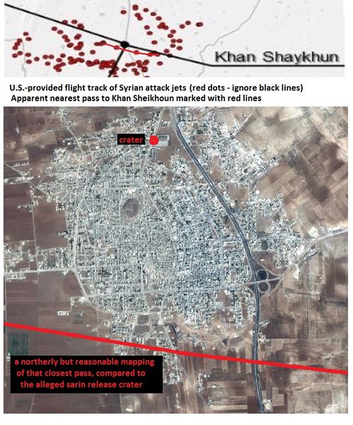
Method: the map from the WHiote House report was overlaid with a real map so Hama to Khan Sheikhoun and all highway bends between matched - no distortion evident, and they lined up well. That has the black dot representing the built-up town, what's gray on a satellite view. So by this, the jets pass just south of the town or, as I fudged it a bit here for a best case scenario for anyone who would want it to be firther north), just over the southern edge of town. I'm not sure which of the two passes this is, 6:37 or 6:46, or which direction it was flying. There's really nop other closest pass - the tracks sort of half-circle the town from a greater distance, passing south about that far out - one long, drawn-out distance pass. --Caustic Logic (talk) 10:26, 3 May 2017 (UTC)
File history
Click on a date/time to view the file as it appeared at that time.
| Date/Time | Thumbnail | Dimensions | User | Comment | |
|---|---|---|---|---|---|
| current | 10:34, 3 May 2017 |  | 714 × 858 (296 KB) | Caustic Logic (talk | contribs) | == Discussion == Method: the map from the WHiote House report was overlaid with a real map so Hama to Khan Sheikhoun and all highway bends between matched - no distortion evident, and they lined up well. That has the black dot representing the built-up... |
You cannot overwrite this file.
File usage
The following page uses this file: