File:20140809-mh17-kaart-fasering-1600.gif
Jump to navigation
Jump to search


Size of this preview: 670 × 600 pixels. Other resolutions: 268 × 240 pixels | 1,323 × 1,184 pixels.
Original file (1,323 × 1,184 pixels, file size: 677 KB, MIME type: image/gif)
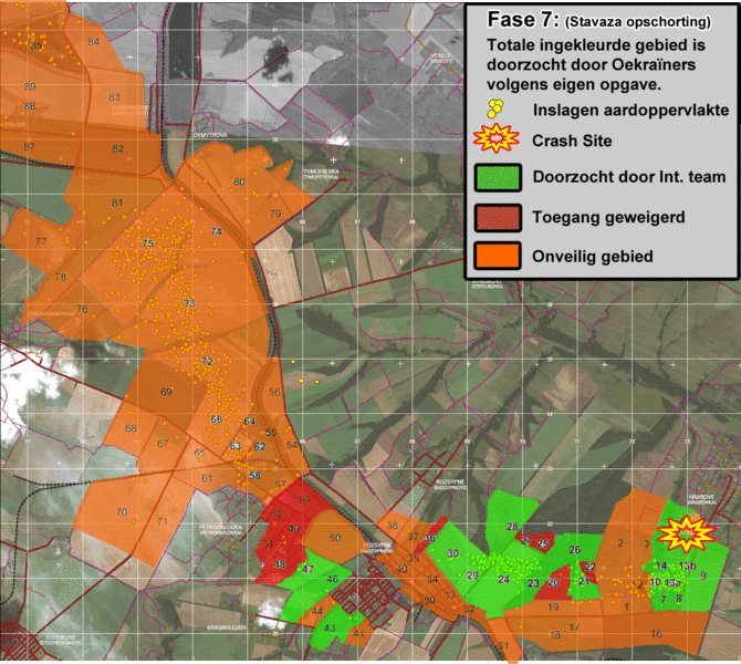
Debris map of MH17 crash from Netherlands Source
Totale ingekleurde gebeid is doorzocht door Oekrainers volgens eigen opgave
- Doorzocht door Int team
- Toegang Geweigerd
- Onveilig Gebied
Total Colored called is searched by Ukrainians, according to their own statements
- Searched by Int. team (Green)
- Access Denied (Brown)
- Unsafe Area (Orange)
Inslagen aardoppervlakte == Impacts Earth's surface (Yellow dots)
File history
Click on a date/time to view the file as it appeared at that time.
| Date/Time | Thumbnail | Dimensions | User | Comment | |
|---|---|---|---|---|---|
| current | 10:10, 10 August 2014 |  | 1,323 × 1,184 (677 KB) | Charles Wood (talk | contribs) | Debris map of MH17 crash from Netherlands Source http://www.rijksoverheid.nl/bestanden/documenten-en-publicaties/kaarten/2014/08/09/kaart-vliegramp-mh17/20140809-mh17-kaart-fasering-1600.gif Totale ingekleurde gebeid is doorzocht door Oekrainers volg... |
You cannot overwrite this file.
File usage
The following page uses this file: